From Ashes to the Spotswood Snuff Industry
According to Clayton’s 1882 History of Union and Middlesex Counties, clear title to the Forge
Company mill seat finally passed in 1796 when it was auctioned off and sold to Daniel Lott for L1275 (the same Daniel Lott
who purchased one of the slaves at the confiscation sale in 1779). The county sheriff sold the property again 1801 to Robinson
Thomas, and in 1819 title to half was purchased by John H. Disborough. He acquired the remaining half interest in 1827. His
name appears conspicuously on the circa 1850 Spotswood map below. His house might have incorporated elements of the Penkridge
Mansion House described in the Loyalist Claim of Perry, Hayes and Sherbrooke.
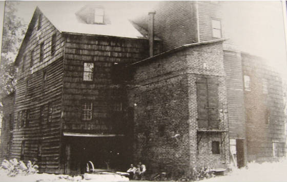
The Penkridge grist mill was located at what would later be known as the old red mill (photographs and maps
show this location). The forge, with its trip hammer illustrated on the margin of the missing original Forge Company map was
on or near the site of the saw mill shown on the ca. 1850 Spotswood map. The old red mill, according to Clayton, was built
in the early 19th century by John Hilliker of Staten Island, on the site of the earlier grist mill. During its construction,
a layer of cinders and scorched corn was dug up, evidence of a fire.
This fire was likely the one mentioned by De Klyne in his Bill of Complaint and also in
the 1786 newspaper notice describing the catastrophe.
The upper forge (Swin Forge) near Helmetta was located along the road known today as Old Forge
Road, which was officially laid out in 1803, although it did replace an earlier one in the vicinity. It ran from Mounts Mill
in Jamesburg to the road leading to Bennett’s mill (saw mill, shown on an 1801 survey map). The site of Swin Forge was
never used for industrial purposes again while the Manalapan stream was dammed for Outcalt’s Mill by 1830. Remains of
this mill, site of Weequehela’s upper saw mill, are still visible to this day.
The Spotswood paper mill, located on the Matchaponix, was still in operation in 1821 when the property was
acquired through auction by Phineas Mundy, Lewis Carmen and James Bishop. Four years later, Mundy bought out his business
partners and continued operating the paper mill. In 1854, he sold the site to Benjamin Skinner, who began the Tecumseh Snuff
Mill. By 1910, according to a Sanborn Insurance Company map, the property was being used as a wood millwork factory. The ruins
of this complex are still visible along the Matchaponix.