Spotswood, New Jersey is a small village nestled along
the confluence of the Manalapan and Matchaponix rivers which form the South River in southern Middlesex County. Surrounded
by pine trees and wetlands, these resources provided a basis for two sawmills operated by a prominent Native American sachem
named Weequehela which developed into a major industrial complex in the years preceeding the American Revolution.
Little was known of this history, with only scattered
and incomplete memories forming the basis for understanding Spotswood’s past. The primary responsibilities of an historian
are to be accurate and thorough. Too much folklore has been accepted as history, and the result is that the beauty and eloquence
of the truth has been obscured by needless embellishments. One immediate example is the ongoing assertion that Spotswood was
founded in 1685 by James Johnston. This piece of folklore is due to the misinterpretation of some letters written by him.
Spotswood, as a place name for the village, does not appear until the mid-18th century. Prior to that, it was usually referred
to as Johnston’s Mills. Even Weequehela’s amazing legacy was corrupted into a handed-down story which claimed
him to be a "half-breed" named McQueely.
In 1727 Weequehela was found guilty of murdering a local
colonist, John Leonard, and was executed in Perth Amboy. A portion of his extensive plantation was claimed by Leonard’s
widow and sold, while the remaining lands were deeded away in 1739. The land encompassed two-and-a half miles of the Manalapan
and South River waterway, future site of subsequent industries.
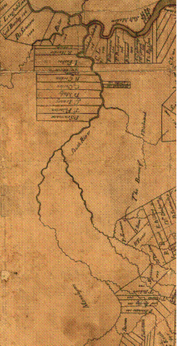
The story of the Spotswood Mills centers on the South
River watershed in southern Middlesex County, New Jersey. The South River is a major tributary to the Raritan River of central
New Jersey, flowing into the latter just before it enters Raritan Bay, which forms part of the New York harbor. Throughout
history, the South River and Raritan estuaries have provided easy transportation for people living and working in the area.
From Native American trading activities at the Roundabout of Edison and Sayreville, to Revolutionary War whaleboat warriors
to ship captains plying lumber and produce to New York, these rivers have been important resources.
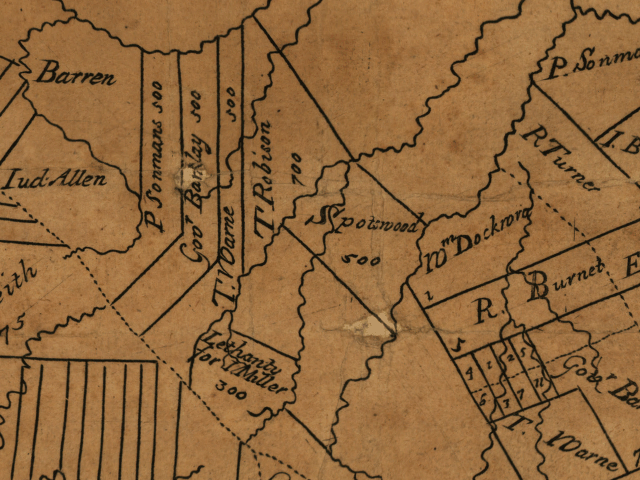
The South River is formed in present-day Spotswood,
by the confluence of the Matchaponix and Manalapan Rivers. Both streams originate in Monmouth County, flow past what was the
Spotswood Patent in present-day Manalapan Township and include numerous smaller streams that played important roles in the
industrial development of this region. Industrial activities included grist mills, saw mills, paper mills, and in the 19th and 20th centuries, tobacco and snuff mills. One prominent stream name that
appears many times is Indian Brook (later, in the 19th century it is called Gulf Brook) which flows into the Spotswood Mill
Pond, now DeVoe Lake, on its southerly shore. Spotswood Avenue crosses this brook at what was historically Couhouses Bridge,
and later the Slab Bridge.
This work reviews the development of three distinct
sets of mills located in the Spotswood area. They are from west to east, or as the Manalapan flows, Swin Forge, Outcalt’s
Mill, and the Spotswood Mills. The Manalapan in this area was first used to power two saw mills operated by an important Indian
sachem, Weequehela. His life bridged the time period from the meager colonization of New Jersey by the Proprietors in the
late 1600s, to the ever expanding colonial population witnessed just before his death in 1727. His plantation and mills were
the key reference points for deeds and surveys for the next fifty years.
Weequehela’s saw mills were located at what was
to become Outcalt’s Mill and the Spotswood Mills. Swin Forge was established in the 1760s and was located near Old Forge
Road in the Helmetta and Monroe area. By the 1770s, Swin Forge had passed into history, while the site of Weequehela’s
upper saw mill was re-activated by the 1820s in the form of Outcalt’s Mill, which in turn eventually became the site
of a physical health community at the turn of the 20th century. The lower saw mill of Weequehela became, first Johnston’s
Mills, then Corne’s in the 1760s, and for a time just prior to the Revolution, Penkridge Forge operated by the impressive
commercial firm of Perry, Hayes and Sherbrooke. Unfortunately for this firm, the two principals lived in England during the
Revolution and Sherbrooke was an active Loyalist. The extensive property was confiscated and sold during the war, but was
the subject of litigation and claims for the next twenty years. Finally, by 1796, the property was auctioned off for the last
time and purchased by local businessmen who transformed the mill seat into a center of snuff manufacturing. By the 1920s,
the mills were in ruins and the memory of the Indian and colonial history of the site was a vague and confused recollection.
For continuity, the three mill sites will be referred
to by their historic names, Swin Forge, Weequehela’s Upper Saw Mill - later Outcalt’s, and Weequehela’s
Lower Saw Mill - later the Spotswood Mills.